


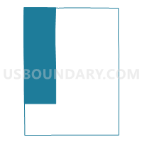
VTD-precinct 4, Hanson County, South Dakota
About
Outline

Summary
| Unique Area Identifier | 667360 |
| Name | VTD-precinct 4 |
| County | Hanson County |
| State | South Dakota |
| Area (square miles) | 108.96 |
| Land Area (square miles) | 108.79 |
| Water Area (square miles) | 0.17 |
| % of Land Area | 99.84 |
| % of Water Area | 0.16 |
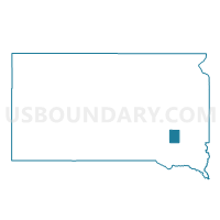
| Latitude of the Internal Point | 43.72085850 |
| Longtitude of the Internal Point | -97.89812530 |
Maps

Graphs
Select a template below for downloading or customizing gragh for VTD-precinct 4, Hanson County, South Dakota


Neighbors
Neighoring Voting District (by Name) Neighboring Voting District on the Map
- VTD - county precinct 1- Badger, Perry & N 1/2 of Mitchell twnships, Davison County, SD
- VTD - county precinct 3 - Beulah, Lisbon, Prosper & S 1/2 of Mitchell twnships, Davison County, SD
- VTD - county precinct 4 - Rome & Tobin twnships & Ethan town, Davison County, SD
- VTD-precinct 1, Sanborn County, SD
- VTD-precinct 3, Hanson County, SD
- VTD-precinct 5, Miner County, SD
- VTD-precinct 5, Hanson County, SD
Top 10 Neighboring County Subdivision (by Population) Neighboring County Subdivision on the Map
- Mitchell UT, Davison County, SD (997)
- Prosper township, Davison County, SD (655)
- Rosedale township, Hanson County, SD (394)
- Beulah township, Hanson County, SD (296)
- Perry township, Davison County, SD (287)
- Hanson township, Hanson County, SD (272)
- Rome township, Davison County, SD (237)
- Wayne township, Hanson County, SD (216)
- Fairview township, Hanson County, SD (162)
- Jasper township, Hanson County, SD (158)
Top 10 Neighboring Unified School District (by Population) Neighboring Unified School District on the Map
- Mitchell School District 17-2, SD (18,417)
- Hanson School District 30-1, SD (1,854)
- Sanborn Central School District 55-5, SD (1,215)
- Ethan School District 17-1, SD (788)
Top 10 Neighboring State Legislative District Lower Chamber (by Population) Neighboring State Legislative District Lower Chamber on the Map
- State House District 25, SD (22,548)
- State House District 20, SD (22,214)
- State House District 8, SD (20,647)
Top 10 Neighboring State Legislative District Upper Chamber (by Population) Neighboring State Legislative District Upper Chamber on the Map
- State Senate District 25, SD (22,548)
- State Senate District 20, SD (22,214)
- State Senate District 8, SD (20,647)
Top 10 Neighboring 111th Congressional District (by Population) Neighboring 111th Congressional District on the Map
Top 10 Neighboring Census Tract (by Population) Neighboring Census Tract on the Map
- Census Tract 9628, Davison County, SD (6,111)
- Census Tract 9627, Davison County, SD (5,467)
- Census Tract 9629, Davison County, SD (5,007)
- Census Tract 9641, Hanson County, SD (3,331)
- Census Tract 9626, Davison County, SD (2,919)
- Census Tract 9616, Miner County, SD (2,389)
- Census Tract 9621, Sanborn County, SD (2,355)